大坑2號登山步道 | Famous Attractions in Taichung City | Taichung's must-see IG photo landmarks: art installations, view cafés, architecture, and creative events, favorite gathering places for young people | Taichung Tourism

大坑2號登山步道

Taiwan Guide Explore Attractions Current city: Taichung City / 22 cities/counties
Taiwan Guide

Explore Attractions

Browse famous attractions across Taiwan, including offshore islands.

22 cities/counties
Spot

大坑2號登山步道

大坑2號登山步道 is a park or outdoor space in Taichung City. The listing is compiled from official Tourism Administration open data, usable photo records, and attraction information.

大坑2號登山步道 is a park or outdoor space in Taichung City. The listing is compiled from official Tourism Administration open data, usable photo records, and attraction information.

Opening hours and on-site rules follow official notices.

Site travel notes

Attraction Guide

This Taichung City travel stop is listed locally as "大坑2號登山步道". This page keeps the local name while organizing the location, opening notes, transport reminders, and sources for trip planning.

This attraction can fit into a Taichung City itinerary. When comparing nearby stops, consider travel time, transport options, and how much energy you want to spend that day.

This attraction is included here because it can add a useful travel stop to a Taichung City itinerary. It works for a half-day visit, a nearby walk, or a smooth link between attractions in the same area.

Use the map link and the saved local address as the location reference, then choose driving, walking, or public transport based on your route. For mountain, island, or high-traffic spots, leave extra time for transfers and queues.

This guide is written from public travel information and our own editorial notes, focusing on details useful for visitors. Live reviews from outside platforms are not rewritten into this page.

FAQ

Where is this attraction?

The local listing name is "大坑2號登山步道". The saved local address is "臺中市北屯區清水巷與連坑巷交會處". Use the map link to confirm entrances, parking, and public transport routes.

What are the opening hours?

Opening hours and on-site rules follow official notices. Check official notices or on-site information before visiting.

How should I plan this stop?

This attraction works well with other stops in Taichung City. Plan the order by travel time, transport distance, weather, and how long you want to stay.

What is the source of this attraction page?

We refer to public travel information, our editorial notes, and verified traveler interest. Reviews from outside platforms remain on their original platforms and are not copied or rewritten here.

Content Source Tourism Administration, MOTC open data 2026-07-04

Check before you go

大坑2號登山步道 Live view and weather

Check the latest conditions before choosing rain gear, layers and arrival time.

Live camera

Nearby camera
大坑2號登山步道 Live camera

This camera is near the attraction and helps with area weather; crowds and clothing may differ at the attraction.

Camera location
Highway 8 at 5K+850 (about 6233 m from the Tourism Administration map point for 大坑2號登山步道)
Source checked
2026-07-27
Open official live camera

The Highway Bureau camera at Highway 8 at 5K+850 is about 6233 m in a straight line from the Tourism Administration map point for 大坑2號登山步道. It shows nearby sky, rain, visibility and road conditions. It is on a nearby road rather than inside the attraction and cannot represent visitor, opening or facility conditions or support reliable clothing checks; review attraction and road notices separately.

Live views are for trip planning only. This site does not identify faces or individuals.

Attraction Video

大坑2號登山步道 Video Guide

Preview the setting and visit highlights. Videos are prioritized from official or operator channels.

Watch on YouTube
Spot-specific guide

Before-you-go questions

Practical notes on transport, parking, food, family needs, pets, tickets, stay time, seniors, and lodging.

10 items

開車去還是搭大眾運輸?

2 號步道入口也在連坑巷系統,開車、騎車較省時間;大眾運輸可查到大坑 1 到 4 號與中正露營區方向的公車,再依入口位置步行銜接。

自駕較省時 公車需銜接
Based on: 大坑風景區交通資訊 Checked: 2026-07-06

好停車嗎?

官方列有停車場與廁所,但熱門假日仍可能不好停。風景區交通頁提醒假日車位不足時,可利用經補庫免費停車場再搭公車進大坑。

有停車廁所 假日車位緊
Based on: 大坑風景區交通資訊 Checked: 2026-07-06

午餐、晚餐如何解決?

2 號是登山路線,不是用餐景點;官方提醒不可生火或用瓦斯爐具。建議帶水、能量補給,下山後再到東山路、大坑商圈吃正餐或點心。

步道無正餐 下山用餐
Based on: 大坑步道爬山後美食整理 Checked: 2026-07-06

適合帶寵物一起去嗎?

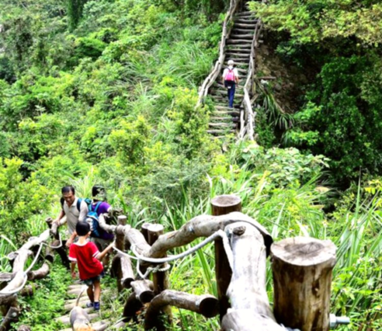
不建議。2 號有 60 到 80 度好漢坡與木棧階梯,對寵物腳掌和體力負擔大;即使是常爬山的狗,也要牽繩、補水並避免人潮尖峰。

不建議寵物 坡度很陡
Based on: 台中觀旅局大坑2號步道 Checked: 2026-07-06

適合嬰兒車嗎?

完全不適合。官方把 2 號列為健腳級,且有非常陡的好漢坡、圓木階梯與需要手腳並用的路段,嬰兒車無法通行。

不適合推車 好漢坡
Based on: 台中觀旅局大坑2號步道 Checked: 2026-07-06

適合帶小孩去嗎?

官方明確提醒 2 號不適合幼兒童、年長者及體力不佳者。若帶孩子,只建議已習慣登山、會遵守步道安全的較大孩子,並避免雨後。

不適合幼兒 較大孩子限定
Based on: 台中觀旅局大坑2號步道 Checked: 2026-07-06

是否需要門票?

不用門票,但需要準備好登山鞋、手套、水與防曬。若風景區公告封閉或天候不佳,就不要進入。

免門票 裝備要準備
Based on: 台中觀旅局大坑2號步道 Checked: 2026-07-06

停留時間要抓多久?

官方標示全長約 1.2 公里、約 1 到 2 小時;因坡度陡,含休息、拍照與下山保守抓 2 到 3 小時較安全。

1到2小時 保守2到3小時
Based on: 台中觀旅局大坑2號步道 Checked: 2026-07-06

適合帶長輩去嗎?

不適合。官方提醒年長者、高血壓及體力不佳者要避免 1 到 5 號和 5-1 號;2 號坡度又特別陡,長輩同行建議改排 6、7、9 類型較平緩路線。

長輩不建議 改排平緩線
Based on: 台中觀旅局大坑2號步道 Checked: 2026-07-06

適合過夜嗎?住宿方便嗎?

單走 2 號不用過夜;若安排大坑步道群、東山路餐飲與溫泉,可以住北屯或大坑溫泉飯店,隔天再走較輕鬆的行程。

不需過夜 可接溫泉住宿
Based on: 台中日光溫泉會館 Checked: 2026-07-06
Google reviews

Google Reviews

Google Maps reviews change over time. Open Google Maps to see the original reviews, latest rating, and newest comments.

Google reviews

Open Google Maps for the latest reviews

Google reviews are updated directly on Google Maps. Open the source page to read the latest public comments.

View on Google Maps

Sources and ranking basis

This page cross-checks official public information, on-site editorial work, and verifiable traveler interest instead of relying on an old or single ranking list.

  1. Official and public sources: Tourism Administration, MOTC open data , Official Info , 愛飄的雲 , Highway Bureau Provincial Road CCTV , Central Weather Administration . Used to confirm the attraction name, address, official links, transportation notes, and basic travel information.
  2. On-site content: Introductions, FAQs, and transportation details are organized into readable original site content. External reviews are not copied into this page.
  3. Ranking and score: The score uses "official inclusion + traveler interest": official sources help decide whether the attraction belongs on the list, while verified ratings, review volume, one-year and five-year activity changes, search interest, and on-site engagement affect the visible recommendation.
  4. Traveler interest references: Google Maps, Tripadvisor, news reports, and public social discussion may be used only as checkable references. The site records usable statistics, source links, and check dates, but does not copy full reviews or posts.
  5. Use of external information: The site uses public, verifiable information for summaries and organization. It does not republish full external reviews, social posts, or entire official pages; images and external materials follow public links, licensing, or source notes.

Page last organized:2026-07-04